![]()
Many of the names of villages in the County of Sussex end in "ing" which indicate their Saxon origins. "Ing" means "people of". Patching originated from "Paecci's people", Paecci being a local Saxon chief or landowner. The village was originally known as Paeccingas but by the time of the Domesday Survey in 1086 the name had corrupted to "Petchinges" and by 1296 to "Passinges" and by 1327 to Pacchyng". By the late 16th Century it appears to have stabilised at "Patching".
Patching, however, had earlier inhabitants. In the 1920's, evidence was found of Bronze and Iron Age farmsteads and field systems on Blackpatch, Harrow Hill and Patching Hill and in 1972 the remains of a Roman house was discovered in the fields to the north of Patching Pond.
The parish of Patching lies on the south slope of the South Downs (hills), about 5 miles west-north-west of the coastal town of Worthing (pop. 100,000). The parish is well wooded, about a seventh of its area being woodland in 1974. The population peaked at about 270 in 1950 but today has fallen to about 200.
The village itself consists of a single street in the south part of the parish (called Patching Street or France Lane) with another road called Coldharbour Lane (previously Deadmans Lane) leading east at the centre of the village to Clapham village about half a mile away. The buildings in the village include several timber-framed houses of the 17th Century, some cased in brick.
In the 10th Century, the manor of Patching was held for King Edgar by Wulfric but by early in the 11th Century it came into the possession of the Archbishop of Canterbury. By the beginning of the 19th Century much of the parish was owned by the Duke of Norfolk, but much was sold off in 1926 and the remainder by 1974. Manor court leet rolls (records) exist for the years 1651-1848.
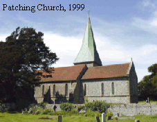 There was a church at Patching in 1086. The
small and pleasant church today is known as St. John the Divine and is built of
flint with stone dressings. Many Pottens are buried there in the churchyard.
The path above the church leads to the top of the hill with fine views of the
beautiful downs in one direction and Worthing and the sea (English Channel) to
the south.
There was a church at Patching in 1086. The
small and pleasant church today is known as St. John the Divine and is built of
flint with stone dressings. Many Pottens are buried there in the churchyard.
The path above the church leads to the top of the hill with fine views of the
beautiful downs in one direction and Worthing and the sea (English Channel) to
the south.
Regarding non-conformity of religion, there is evidence of recusancy (i.e. those refusing to attend Church of England services) at Patching in the later 16th Century and at least 9 recusants were recorded between 1620 and 1640. The recusancy does not appear to have remained strong as there was only one recusant in 1662 and none in 1676.
Prior to the mid-20th Century, the principal industries were farming and wood supply/manufacturing. Timber was supplied to local communities; the production of hurdle fencing which was primarily used for the penning of sheep. (see The Pottens of Patching). Today, little is left of that industry, most inhabitants working in Worthing or further afield.
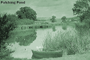 An inn had been established by
1765 and this was called "Patching Pond House" as it lay by the village pond at
the bottom of Fox Hill. By 1847 it had been renamed "The Horse and Groom". By
the late 1980's it had been completely modernised and a restaurant added. In
2002 it was again refurbished and the name changed to "The World's End", a name
not liked by locals but probably necessary to promote an image
change.
An inn had been established by
1765 and this was called "Patching Pond House" as it lay by the village pond at
the bottom of Fox Hill. By 1847 it had been renamed "The Horse and Groom". By
the late 1980's it had been completely modernised and a restaurant added. In
2002 it was again refurbished and the name changed to "The World's End", a name
not liked by locals but probably necessary to promote an image
change.
In the 19th Century, Patching was renowned for its truffles which grew in the beech woods. It also had a reputation for the production of superb butter from the downland farms in the parish.
Sussex is renowned for its custom of observing Guy Fawkes celebrations. Lewes is the centre of such celebrations having some nine bonfire societies established in the town. Clapham and Patching formed its own bonfire club in 1951 and it still exists today.
December 2000 saw the launch of
"Bricks & Water - 100 years of Social History in Clapham & Patching
Villages", a book to commemorate the Millennium and illustrate the profound
social change in those villages between 1900 and 2000. The authors and
compilers, village residents David Gillard, Sir Richard Best, Ed Bacon and Tony
Crowther have produced an outstanding record of life in the villages including
the churches, the houses, the school, working life, sport and leisure, village
events, and much more. The 280 page book is superbly illustrated with over 600
photos. Local families are well represented in the book and these include the
Averys, Barrons, Bishops, Bookers, Burchfields, Cornfords, Drewitts, Evans,
Fields, Gents, Harveys, Jenkins, Kinnards, Latters, Phillips, Pottens, Searles, Somersets,
Stanfords, Whites, and many more. Proceeds of the sale of the book went to the
village churches. Video slideshows of the making of the book were launched in
2001 in aid of the refurbishment of Clapham & Patching Village
Hall.
A delightful illustrated and informative Millennium map of Clapham
& Patching was finalised in 2001 and copies were made available for sale.
The map contained sketches/paintings of birds, plants, and many of the old
buildings of the twin villages, surnames of families in the villages in 2000,
names of children attending the Primary School, and village businesses and
organisations.
Updated May 2002
| Welcome Page | Potten Index |